We’re thrilled to partner with our historic peers, the Friends of the History Center, to present two special programs this season.
Wednesday January 24, 2024 at 2pm in the Crocker Memorial Church
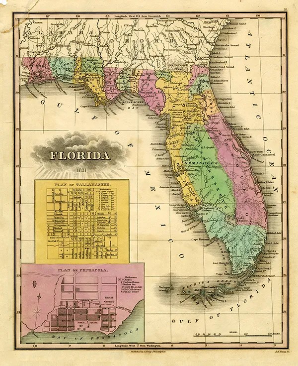
How Florida Got Its Shape – Of the fifty states, Florida has one of the most distinctive and widely recognized shapes. But how did that familiar shape come to exist? Obviously the state’s 1,350-mile coastline defines the majority of it, but what about its borders to the north and west? It might surprise you to learn that “Florida” has at various times stretched as far north as present-day Virginia and as far west as the Mississippi River. The current shape of Florida was settled during a fascinating era before the region was a U.S. state. In those days, Florida was actually an international borderland. Join the staff of the Sarasota County History Center for a brief journey into that era–illustrated with maps and records explaining exactly how and why Florida acquired its well-known shape.
Wednesday February 21 at 2pm in the Crocker Memorial Church
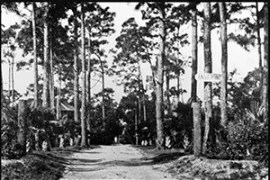
The Tamiami Trail and the Development of Florida’s Gulf Coast in the 1920s – The 275-mile stretch of U.S. Highway 41 between Tampa and Miami is called the Tamiami Trail. To the casual observer it looks like every other major highway in the area, but this strip of pavement played a big role in the development of Florida’s Gulf coast. Because of its route through the Everglades, it was in many ways an engineering marvel of its time, and it even resulted in the creation of a new county! Join the staff of the Sarasota County History Center for a closer look at the fascinating history of this iconic scenic Florida byway and its impact on the Gulf coast.

